Panama City Beach: which government, which neighborhood, and one bridge
Panama City Beach is four things a visitor tends to treat as one. It is a city with its own council, ordinances and paid lots. It is a beach that a different government runs in places. It is a peninsula whose east end — Thomas Drive, Grand Lagoon, Bay Point — is not in the city at all but in unincorporated Bay County. And it is a separate municipality from Panama City, the mainland bay town across the water. A reader who gets that wrong calls the wrong office, parks under the wrong rules, and looks for a lifeguard where nobody staffs one.
The second structural fact is the bridge. The Hathaway Bridge, carrying US-98 over St. Andrew Bay, is the only roadway crossing between mainland Panama City and this peninsula. Every vehicle leaving — grocery run, hospital visit, hurricane evacuation — funnels across one span, and that span is inside an active multi-year widening programme. That is why this page treats bridge status as a trip-planning fact rather than a traffic complaint. This record orients; the five neighborhood pages under it carry the detail.
At a glance
| Decision | Answer |
|---|---|
| Best for | Travelers who want Gulf-front lodging with a beach at the door, families who want a condo with a kitchen rather than a hotel room, and anyone whose trip is built around the water — boats, charters, piers, state parks |
| Less ideal for | Anyone expecting a walkable resort town. The corridor reads as one continuous strip on a map and does not behave like one on foot. Also a poor fit for anyone who needs to know a rule before they book: several of the rules here are genuinely unsettled and this page says so rather than guessing |
| Who governs it | Four bodies at once. The City of Panama City Beach, unincorporated Bay County, the State of Florida at St. Andrews State Park and Camp Helen State Park, and federal land at the east end of Shell Island. Carillon Beach at the far west is a private gated community on top of that |
| Getting off the peninsula | One roadway crossing: the Hathaway Bridge, US-98 over St. Andrew Bay. There is no second span. SR-79 runs north from its terminus at US-98 in Panama City Beach and is the road that brings most arrivals down from I-10 |
| Lodging shape | Overwhelmingly independently owned condominium units in high-rise towers, marketed by third-party rental managers — not chain hotels, whatever the listing name suggests. Branded hotels exist but are the minority of the inventory |
| Lifeguards | Three fixed locations are confirmed: Russell-Fields City Pier, Rick Seltzer Park, and M.B. Miller County Pier. We publish no season, no hours and no staffing count — see the beach safety section for why that restraint is deliberate |
| Beach access count | We do not publish one. The numbering is non-consecutive and split between two governments, and the one published total contradicts the split. A rounded figure would be a different error wearing a hedge |
| Spring 2026 rules | Short-term rentals could not be rented to anyone under 21; a High Impact Period ran 28 March to 11 April 2026; beach alcohol was banned through March; two separate stretches of beach closed overnight from 12 March to 30 April 2026. No 2027 dates are published here |
| Closest airport | Northwest Florida Beaches International (ECP), in West Bay — unincorporated Bay County, north of the peninsula, not on it. The airport publishes a flat 20 minutes to Pier Park and central Panama City Beach. That figure does not cover the east end and we do not stretch it |
| Car dependence | High, with one real exception. The immediate Pier Park vicinity works on foot. Bay County transit runs an on-demand zone that reaches into Panama City Beach, but the operator publishes no eastern boundary for it, so we cannot tell you whether it reaches Pier Park |
Primary actions, and the anchor guides for this destination
Start here, then go to the neighborhood page for the end of the beach you are actually choosing.
The guides below go deeper than this page on a single question each, and every one of them inherits the same rule: nothing publishes that does not trace to the Region B research file. The ready-made itineraries for this coast are the 3-day family and 3-day couples trips, the 5-day family stay, and the budget weekend.
- Build a trip based here: /plan?base=panama-city-beach
- Check conditions on this stretch today: /beach-today?zone=gulf-panama-city-beach
- Work out which neighborhood you actually want: see the five-neighborhood table below, then open that neighborhood page
- Panama City Beach Without a Car — transit, on-demand service, carts and LSVs, and what is genuinely walkable
- Panama City Beach Spring Break Rules 2026 — the ordinances, the High Impact Period, and the two overnight beach closures
- Things to Do in Panama City Beach, With a Real Plan for Bad Weather — the verified indoor inventory for the day the sky closes in or the water is off limits
- The Condo Check-In Guide — what an individually owned unit under a third-party manager actually asks of you
- A Panama City Beach Trip Under $1,000 — where the money actually goes on this coast
- Panama City Beach Hidden Gems — the quieter end of the inventory
- The Panama City Beach Events Calendar — with the standing warning that last year's date is not this year's fact
- Where to Eat Near Pier Park — the one dining cluster dense enough to walk
Who should base here — and who should not
Base here if the beach is the trip. This is the straightforward reason and it is a good one. The Gulf frontage runs the length of the peninsula, the lodging sits on it, and the two state parks at either end — St. Andrews at the east, Camp Helen at the far west — give you shoreline that is not condo frontage. Panama City across the bridge has no Gulf beach at all.
Base here if you want a condo rather than a hotel room. The dominant product is an individually owned unit inside a high-rise, with a kitchen, a washer and a balcony, rented through a management company. That is a different trip from a hotel trip, and the where-to-stay section below explains why it also means the policy you read may not be the policy you get.
Base here if your trip is on the water. Charter fishing, dive shops, pontoon and paddle rental, the two piers, and boat access to Shell Island all work out of this peninsula. Read the jurisdiction section first, because several of those operators sit on the unincorporated county side and are governed accordingly.
Consider another base if any of these is true:
- You want to walk everywhere. The corridor is long and the pedestrian environment is not continuous — see the getting-around section, which states plainly what is judgment and what is sourced.
- You want a downtown. Panama City, across the bridge, is the bay town with the Harrison Avenue core and the historic St. Andrews blocks. That is a different record on this site.
- You are traveling in March. Spring enforcement here is real and specific, and it is not the same rulebook as the rest of the year.
- You need certainty about a fee, an opening time or a boundary before you book. This page carries a long list of things nobody has confirmed, and we would rather hand you the phone number than a plausible number.
| Alternative | Why choose it instead | What you lose |
|---|---|---|
| Panama City (mainland, across the Hathaway Bridge) | A real downtown, a working marina district, historic neighborhoods, and no Gulf-front pricing | No Gulf beach anywhere in the city. Every beach day becomes a bridge crossing on a road inside a work zone |
| Thomas Drive and Grand Lagoon (unincorporated Bay County, at the east end of this peninsula) | The marina and charter cluster, a county pier and a county park with lifeguards, and quieter frontage than the central strip | It is not the City of Panama City Beach. City ordinances, city paid parking and city beach safety do not apply, and the exact line is not settled in our sources |
| Carillon Beach, at the far west end | The quiet end of the peninsula. Bay County publishes a public beach access here — Access 97, a wooden boardwalk five feet wide | The community itself is private and gated, its eight HOA walkovers are not public access, and a member of the public using the county access checks in at the security gate. West End accesses have limited spots |
| 30A and the Walton County beaches, west past the county line | Low-rise scale and a different character entirely | A different county with a different tourism authority. We hold no sourced Panama City Beach to 30A mileage or drive time and will not estimate one |
Jurisdiction: four governments, one strip of sand
This is the spine of the page. Ownership here is not trivia — it decides parking rules, fees, ordinances, flag authority and lifeguard staffing, and those change across a boundary you cannot see from the sand.
Bay County publishes a contact list naming exactly seven incorporated municipalities in the county: Callaway, Lynn Haven, Mexico Beach, Panama City, Panama City Beach, Parker, and Springfield. Bay Point does not appear on it. Neither does Upper Grand Lagoon. They are unincorporated Bay County, and the county GIS boundary layer records the legal lines that do exist.
The five neighborhood names this site uses for Panama City Beach are informal marketing geography. They are published by the destination marketing organisation, not by a government, and none of them appears among the legal boundaries. Crossing between them changes nothing about which law applies. The legal lines cut across them and are stated on their own terms.
| Place | Governed by | What that changes for you |
|---|---|---|
| The central beach strip | City of Panama City Beach | City ordinances, the three city paid lots, and the City beach safety programme at Russell-Fields City Pier |
| Thomas Drive, Grand Lagoon, Bay Point | Unincorporated Bay County | Not the city. County facilities interleave with city ones along the same road — a county pier and a county park sit near a city paid lot. Ask the county, not the city |
| Carillon Beach | Private, gated community — plus county Access 97 on the same ground | The HOA walkovers are private and are never public access. County Access 97 is public, and the public checks in at the security gate to use it |
| St. Andrews State Park, and the western portion of Shell Island | State of Florida | State park hours, fees and rules. Ferry and shuttle passengers land on the state park section of the island |
| The east end of Shell Island | Tyndall Air Force Base (federal) | Federal military land, sharing a property line with the park on the east end. The base recreation permit framing applies here and only here |
| Signal Hill Golf Course | Unresolved | Its listings carry a Panama City address. Whether that is an address convention or a genuine location outside city limits is not settled in our sources |
The county publishes the seven municipalities and the boundary layer; the state publishes the Shell Island split in its approved park management plan. The private and gated status of Carillon Beach rests on a rental agency page, because the community's own site refused every request.
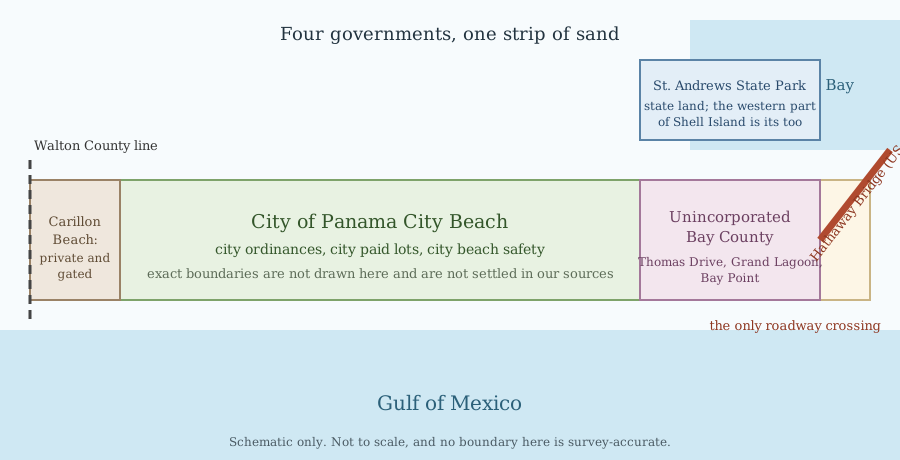
The map above, in words
This section is the text equivalent of the diagram above. It carries the same facts in the same order, so a reader who cannot see the map still learns which government to call. Nothing here is decoration and nothing here is only in the picture.
The shape of the place. Panama City Beach is a peninsula. The Hathaway Bridge, carrying US-98 over St. Andrew Bay, is the only roadway crossing between mainland Panama City and it. There is no second span. St. Andrew Bay lies to the north and east of the strip, the Gulf of Mexico to the south, and inland Bay County to the north and west. Front Beach Road, which is SR-30, and Panama City Beach Parkway, which is US-98 and is locally called Back Beach Road, run the length of the strip in parallel and less than a mile apart, which is why an address rather than an area name is the only reliable way to say where something is.
Why the airport road does not use the bridge. SR-79 comes down from the north and ends at US-98 on the peninsula itself, in west-central Panama City Beach, where its former Y intersection with Front Beach Road was replaced by a roundabout in 2023. Northwest Florida Beaches International is north of the peninsula rather than on it. A driver coming down SR-79 therefore reaches the beach without crossing the bay. That last sentence is read off the road geography rather than quoted from a routing page, and it is stated that way deliberately.
The two ends. Camp Helen State Park is at the west end and is the landmark boundary of the West End sub-region. St. Andrews State Park is at the east end. Both are State of Florida land. St. Andrews also holds the western half of Shell Island, which is the half ferry and shuttle passengers reach; the east end of the island is Tyndall Air Force Base. The property line between them is not mapped in our sources, so the map does not draw it. Off the west edge of the diagram is the Walton County line, a different county.
The two piers. Russell-Fields City Pier is run by the City of Panama City Beach. M.B. Miller County Pier, at 12213 Front Beach Road, is run by Bay County. Fees and staffing do not cross over between them, which is the reason both appear on the map with the government named underneath rather than as two identical dots.
The seams, which are the reason the map exists. These are the lines that decide which office answers your call, and the list below is what the diagram shows.
- City of Panama City Beach — the central stretch. City ordinances, the three city paid lots, and city beach safety.
- Unincorporated Bay County — Thomas Drive, Grand Lagoon and Bay Point. This is not the city. City ordinances, city paid parking and city beach safety do not apply here. Bay County's own list of the seven municipalities in the county does not include either Bay Point or Upper Grand Lagoon.
- Unresolved, drawn as a hatched band with a question mark rather than as a line — where the city limit actually falls along Thomas Drive, and where it falls at the western end. No source we could read publishes either line, and a county pier sits near a city paid lot on the same road, so the interleaving is real rather than a drafting error.
- State of Florida — Camp Helen State Park at the west end, St. Andrews State Park at the east.
- Private and gated — Carillon Beach, in the West End, drawn as a marker rather than a bounded area because no boundary for it is published. Its HOA walkovers are never public access. County Access 97 at the same place is public, and a member of the public checks in at the security gate to use it.
- Unresolved — Signal Hill Golf Course, 9615 Thomas Dr. Its own listings carry a Panama City address, and whether that is a postal convention or a genuine location outside city limits is not settled in our sources.
Where the five neighborhood names sit, and what the map does not draw
The map places the five names along the strip in the order West End, Pier Park, Open Sands, Middle Beach, Grand Lagoon, running west to east. That order follows the Front Beach Road address clustering this record already relies on — the West End properties carry the highest street numbers and run out to Camp Helen State Park at 23937 Panama City Beach Parkway, Pier Park sits in the sixteen-thousands, the Open Sands towers in the fourteen and fifteen-thousands, and the Middle Beach anchor at 11212 Front Beach Road sits east of them, with Grand Lagoon on Thomas Drive beyond that. It is the only positional evidence we hold and it is not an official ordering.
What the map deliberately does not draw is a boundary between any two of them. No source we could read maps these five names at all, so every internal line would be somebody's inference rendered as fact. They are marketing geography published by a promoter, not governments, and crossing from one into another changes no rule, no fee and no authority.
One naming trap is printed on the map itself because it catches people every season. Middle Beach is a marketing name for a stretch of Front Beach Road condominiums. Middle Beach Road is a local name for Hutchison Boulevard, SR-392A, an inland connector running to Thomas Drive at the east end of the beach. They are different things on different roads. A property advertised in Middle Beach is not on Middle Beach Road, and the map names both only so that the difference cannot be missed.
Two things are absent from the map on purpose. There is no beach-access count on it, because the published totals contradict each other and the round-number phrasing in circulation is the same unverified figure with the source filed off. And there is no drive time on it, because drive times here differ by sub-region and none of them belongs on a diagram that shows no distances.
The Hathaway Bridge, and what one crossing means
The Hathaway Bridge carries US-98 over St. Andrew Bay and is the only roadway crossing between mainland Panama City and the Panama City Beach peninsula. There is no second span. Every vehicle leaving the peninsula uses it.
Two consequences follow, and they are worth separating. The first is ordinary: a trip to the mainland is a bridge trip, and bridge conditions decide how long it takes. The second is not ordinary: the bridge approach sits inside an active FDOT widening of US-98, locally Back Beach Road, from four lanes to six with new sidewalks, bicycle lanes and traffic-signal improvements. The speed limit approaching the bridge was reduced to 35 mph in June 2026 and speeding fines are doubled in the work zone.
We publish no cost figure and no completion year for that widening. One outlet, across three articles in five weeks, gave the programme as $169 million, as over $200 million, and as $97 million, and gave one segment alone as $59 million. Those are not four versions of one number; they are different numbers describing different things, and nothing we hold distinguishes them. A range would imply a single project of uncertain price, which is itself the error.
Do not confuse the Hathaway with the DuPont Bridge replacement. The DuPont crossing is over East Bay, connecting mainland Bay County to the Tyndall and Callaway side. It is a different corridor and it is not an alternate route to the beach.
There is a second and separate roadworks story on this peninsula, and merging the two is the common mistake. The city redevelopment agency is rebuilding Front Beach Road in numbered segments. Its Segment 4.1 and 4.2 are in permitting and its Segment 4.3 is in right-of-way acquisition — none has broken ground, which means no new streetscape there and no construction delays there either. The cones are at the bridge end. Note that the state programme and the city programme each have a Segment 3, on parallel roads half a mile apart, sharing Richard Jackson Boulevard as a boundary street. Any sentence naming a segment number has to name the agency and the road with it.
Inside Panama City Beach: the five neighborhoods
The tourism board publishes five regions for this coast — Grand Lagoon, Middle Beach, Open Sands, Pier Park and West End — and address clustering along Front Beach Road corroborates them. They are marketing geography, and several properties sit on a seam. A neighborhood name settles nothing about jurisdiction and nothing about which region a seam property belongs to.
One naming trap before the table, because it catches people every season. Middle Beach Road is a local name for Hutchison Boulevard, an inland connector at the east end of the beach. Middle Beach is a marketing sub-region of Front Beach Road condominiums further west. Same name, two different things, at different ends of the beach. A property advertised in Middle Beach is not on Middle Beach Road.
| Neighborhood | Who it is for | The thing to know first |
|---|---|---|
| Grand Lagoon | Boaters, anglers and divers — the marina and charter cluster, plus the gated golf-and-marina community at Bay Point | Much of it is unincorporated Bay County, not the city. Several properties here front bay, lagoon or marina water rather than the Gulf |
| Pier Park | Anyone who wants to park once and walk — the open-air retail and dining centre, and the small cluster of condominiums and hotels around it | Pier Park is not enclosed and it is not beachfront. The centre sits at 600 Pier Park Dr with frontage on both the Parkway and Front Beach Road, set back from the Gulf |
| Open Sands | Travelers who want a Gulf-front high-rise on the central strip, and are choosing the building rather than a brand | The towers here are independently owned condominiums. No official address range for this region is published anywhere, so treat any boundary you read as somebody's inference |
| Middle Beach | Travelers who want the central strip with a slightly narrower official footprint and a mix of condo and resort product | The tourism board names only two properties for this region, and that narrowness is the finding rather than a gap to fill in with neighbours |
| West End | Travelers who want the quiet end — fewer high-rises, a more residential feel, and Camp Helen State Park at the outer edge | Carillon Beach sits here, private and gated, alongside county Access 97 which is public. West End accesses have limited spots and check-in at the security gate |
The tourism board is a promoter, not a governing authority. It may describe a facility; it may not settle a jurisdiction question.
Beach access: what is published, and the number we will not print
Bay County publishes its beach accesses grouped by area, and the groups are exact: Spyglass Drive 1 to 3, Gulf Drive 4 to 15, Surf Drive 16 to 23, Laguna Beach 77 to 85, Hollywood Beach 86 to 96, and West End 97 and 98. Access 97 is Carillon Beach, a wooden boardwalk five feet wide; Access 98 is Pinnacle Port. The county's own note on that West End group is that spots are limited and that the public checks in at the security gate.
We do not publish a total. The numbering is non-consecutive and split between two governments, and the one published total in circulation attributes the whole inventory to a single one of them, which contradicts the split. Recording that figure is not the same as clearing it, and the count stays unpublishable until somebody makes the call.
The hedge is banned here for a specific reason rather than a stylistic one. The same publisher that gives the total also writes it in prose as a round-number phrase, so writing the hedge ships the same unverified figure with the source filed off. A reader cannot tell the two apart, and neither can a fact-checker.
Access 22 on Surf Drive is Edward F. Hickey Jr. Park, a Bay County facility and the best-documented accessible beach setup in our research. It carries accessible parking, an accessible beach ramp, and over 100 feet of mobility mats running from the sand to the shoreline. It was unveiled on 15 April 2025, and the same reporting notes an observation deck as a later phase — so that is the unveiling of a project still in stages, not a completion. It is also being replicated: the county has since procured an ADA rebuild of Access 16.
Beach safety and the three lifeguard locations
Three fixed lifeguard locations are confirmed on this coast: Russell-Fields City Pier, Rick Seltzer Park, and M.B. Miller County Pier. The rest of the City beaches are monitored, in the City's own words, primarily on a roving as-needed basis. No fourth fixed location was found in any source we could read.
We publish no lifeguard season, no daily hours and no staffing count, and the restraint is deliberate rather than cautious. The one documented staffing window belongs to the Russell-Fields City Pier specifically. Two City pages agree on it, and two sources agreeing on a narrow fact does not widen the fact — it establishes nothing about the county pier, nothing about Rick Seltzer Park, nothing about the roving patrol, and nothing about the unguarded majority of this shoreline. The City's own two pages also disagree with each other on how many full-time responders there are, and we do not reconcile that by averaging.
Bay County publishes a Surf Rescue Division page separately from the City's beach safety programme. It names no stationed locations, no staffing count, no season and no hours, so no coverage claim comes out of it in either direction.
Ownership changes the answer at each pier, which is why the table below names who runs each one. A page that lists the three together without that column is telling you the same rules apply at all three. They do not.
| Site | Run by | Admission | Lifeguards |
|---|---|---|---|
| Russell-Fields City Pier | City of Panama City Beach | Not published here. Two marketing publishers give different walking fees and the operating authority's own site carries neither figure | Fixed location — beach safety responders staff the east and west sides |
| M.B. Miller County Pier, 12213 Front Beach Rd | Bay County | The county publishes a two-part structure: spectators $3 daily; fishing $6 daily for anyone over 6 years of age; no charge for children 6 and under; $3 concession for registered disabled, active military, and seniors 65 and over. Open 24/7 | Fixed location — the county lists a lifeguarded beach |
| Rick Seltzer Park, 7419 Thomas Drive | Bay County | Not applicable. The county lists beach access with mobility mats, boardwalk, gazebo, parking and restrooms | Fixed location — the county lists a lifeguarded beach |
The two piers charge different amounts and one pier's fees may never be applied to the other. Bay County also states that annual passes sold at Frank Brown Park are honoured at both piers; the price and where they are sold are unconfirmed.
Parking
City-run paid parking is exactly three lots. They take Passport Parking, online or through the app. The county pier runs its own separate lot, which is not one of the three and must not be folded into a city table.
Overnight parking is allowed only in those three city lots, and trailers, RVs and oversized vehicles are prohibited from parking there overnight. The word overnight is the fact, not a qualifier on it: the City documents no daytime restriction, and its silence is not permission either. We say what the overnight rule is and say nothing about daytime.
On peak-summer overflow and towing, the honest answer is that no city or county policy statement exists in anything we could read. That absence is the finding. We will not write that parking can be tight in summer, or that spaces fill up fast, or that you should arrive early — each of those asserts a capacity claim nobody published, wearing the costume of caution. A reader told that no policy is published, and given the number to call, knows what to do next.
| Lot | Address | Rate |
|---|---|---|
| Thomas Drive | 9941 Thomas Drive | $2 per hour, up to 6 hours |
| Henley Drive | 600 Henley Drive, at Churchwell and Front Beach Road | $12 per day, 24 hours |
| Front Beach Road | 11209 Front Beach Road, at Richard Jackson Boulevard | $84 per week |
The three rates apply across all three lots; they are listed one per row only because the City publishes them as one rate card. Rates are the City's own, from its public parking page. The county pier lot is separate and its rate is unconfirmed here.
Spring break, the High Impact Period, and the two overnight beach closures
Short-term and vacation rentals are prohibited from renting to anyone under the age of 21. It is not one law but a pair of mirror ordinances: the city passed the prohibition around September 2025 and the county adopted an essentially identical one about a month later, in October 2025, so the rule would not stop at a line visitors cannot see. What we cannot tell you is the rule's geographic footprint. One source frames it as a general ordinance-wide restriction and another frames High Impact Period rental restrictions as zone-specific, and those produce materially different answers for someone booking outside the zones. So we state the rule and attach no footprint to it in either direction.
The 2026 High Impact Period ran 28 March to 11 April. During it, police held expanded enforcement authority over curfews, bars, vacation rentals, traffic and beach closures. An 8 p.m. to 5 a.m. curfew applied to unaccompanied minors under 18 within the designated zone; the county states that a violation is a second-degree misdemeanour punishable by up to 60 days in jail and a civil fine, with parents or guardians also exposed. A full beach alcohol ban applied for the entire month of March.
The zone boundaries themselves are not published here. Three dated local reports describe the city zones three different ways, naming streets that appear in none of the others, and the county's own zone map is a document we could not read. A zone boundary is the line between lawful and cordoned, and we will not draw it from three disagreeing accounts.
The overnight beach closures are the item to read twice, because they are TWO stretches and not one. From 12 March to 30 April 2026, nightly between 10 p.m. and 4 a.m., the beach was closed from about Beach Access 25 to Beach Access 36, and separately from about Beach Access 58 east to the east end property line of the Calypso Condominiums. Access 58 is the western end of a second closed run, not a single closed access. Written as one range, it tells a reader everything east of 58 is open, and it is not. The reporting hedges both endpoints with the words from about, and we do not sharpen them.
That closure window is longer than the High Impact Period and the two must not be collapsed into one span. One more distinction: many individual buildings run their own year-round minimum check-in ages that have nothing to do with any of this. A house rule is not an ordinance, and writing either as the other misdescribes both.
No 2027 dates are published on this page. When the season's dates are set they will come from the city and the county, not from a repeat of last year.
Where to stay: the structural fact that governs every listing
Almost no Panama City Beach high-rise is a branded hotel. What looks like a chain property is nearly always an independently owned condominium building marketed by a third-party rental management company, and multiple competing managers often list the same building. Two rules fall out of that and they carry the whole lodging picture on this coast. Never call a condo tower a hotel brand — the name on the listing is the manager's, not the building's. And never take a building-wide policy from a single manager listing, because policies vary by individually owned unit and by manager. One listing is evidence about one unit under one manager and nothing more.
There is no citywide resort-fee standard. Observed charges run from none at all to about $5.95 per day plus tax, and one property that advertises no resort fee charges $15 per day for self-parking — so no resort fee is not the same as no mandatory charge. Most independent towers publish no fixed resort fee but do charge cleaning, damage-waiver or reservation fees that vary per unit and per manager.
There is no citywide pet policy either, and we do not publish a distribution. Individual policies are sourced building by building on the neighborhood pages. Minimum-stay rules could not be verified for any property in the central strip — every official rental policy page we fetched either omitted stay-length rules or gave only a spring-break minimum. Treat that as a universal gap and ask the manager.
The winter long-stay market is genuinely active — several rental companies run dedicated snowbird programmes with their own landing pages. What we cannot give you is its shape. No city or county statistic quantifies it, no published season length exists, and any specific discount figure in circulation is one company's offer on its own inventory rather than a market rate. Long-stay inventory appears across the peninsula rather than concentrated in one district, and we do not invent a snowbird district that nobody documents.
Accessibility: documented is not the same as available
Panama City Beach runs a named accessibility initiative in partnership with an accessible-travel booking platform, which has awarded the destination a verification seal and maintains an assessed list of local partners. That the initiative exists is well established. What it certifies about any individual room is not.
The older tourism-board page names four lodging properties as accessible; the board's current page names six and calls even that a preview. Both pages are live, neither supersedes the other on its face, and we report that rather than picking a list. Itemised room features are published for some of those properties by the platform's own blog, and not for others — so the flat statement that no features are published anywhere is wrong, and the instruction to confirm with the property directly is still right. A two-year-old feature description is not a booking guarantee.
Separately, the best individually documented features in our research sit at properties the initiative does not name — roll-in showers, pool lifts, hearing-accessible rooms, full elevator access, on-site mobility scooter and beach wheelchair rental. The two lists barely overlap, and a property appearing on one says nothing about the other.
Everywhere else, accessibility is undocumented rather than absent, and that distinction is the whole of this section. A property not named here is not a property without access. Do not infer compliance from a listing photo or a generic accessible tag on a booking channel. This is the single largest verified gap across our whole lodging survey, and stating it plainly serves a wheelchair user better than a confident amenity list that goes quiet on access.
On the sand, the best-documented accessible setup is Edward F. Hickey Jr. Park at Access 22, described above.
Eat and drink
The dining detail lives on the five neighborhood pages, because where you eat here is decided by which end of the peninsula you are on and not by a citywide list. What belongs on this page is the two traps that apply everywhere.
First: operating status. A large share of the restaurant names in circulation for this coast could not be confirmed as currently trading from any operator source, and several sit behind sites that refused every request. We do not list a venue as open on the strength of a directory entry, and we do not publish an hour or a weekly closure day we have not read on the operator's own page.
Second: two directories can file the same business in two different neighborhoods, or give two businesses the same address. Where that happens we say so rather than picking the tidier version.
One confident negative that was already tested and failed: it is not true that Panama City Beach has no independent coffee shop. Two are operator-confirmed. We record that here because it is the exact failure mode this whole page is built to avoid — of five no-X-exists claims tested on this project, three were false and two were merely undisproven. None was established.
Things to do, and how this page handles opening status
One rule governs everything in this section: a closed attraction is never listed as open. Not in a table, not in a round-up, not in a sentence beginning if you have time, and not as a name dropped without a status. A reader who drives a family to a locked gate cannot recover the afternoon, and the site is what sent them.
That rule bites here specifically. A large marine park on this coast is permanently closed — its last guests were on 28 May 2025, and it was sold out of bankruptcy in 2025 with no plans published to restore marine operations. Its website is live again carrying a bankruptcy notice, which is exactly how a closed attraction ends up back on a round-up. A long-standing golf club closed in October 2018 and will not reopen. Neither appears on this site as an option.
What is confirmed and worth planning around: Pier Park, an open-air lifestyle retail and dining centre at 600 Pier Park Dr — open-air matters, because the walkways between tenants are not shelter and a reader told mall will assume otherwise. Conservation Park, run by the city, is 2,900 acres of restored wetland and pine forest, free, open dawn to dusk seven days a week; the restoration does a job, filtering water before it reaches the bay. St. Andrews State Park at the east end and Camp Helen State Park at the far west are both state parks with their own hours and fee ladders, and those fees are on our open list rather than on this page. Gayle's Trails is a real multi-use trail network associated with Conservation Park; its mileage is not published here because the city trail map would not load and two other published figures disagree.
Shell Island deserves its own paragraph, because it is split three ways and the split is load-bearing. The western half is St. Andrews State Park and that is the section ferry and shuttle visitors reach. The eastern half is Tyndall Air Force Base, sharing a property line with the park. And in the middle, at the most popular boat anchorage on the island, sits a third jurisdiction that is neither: the Spanish Ante Subdivision of private lots and county roads. That halves-plus-subdivision wording rests on a single advocacy group with a stated adversarial history with the park rather than on a governing authority, and the caveat travels with it. Never write the island as wholly one owner's, and never as only two owners'. And never use the bare phrase Shell Island ferry without naming the dock: the in-park boat leaves the state park marina and a separately trademarked shuttle leaves a Grand Lagoon address, and they are different operations at different docks.
On events: this coast runs a full annual calendar, and we publish a date only where an official source carries it for the season in question. Several recurring events in circulation carry no verified date for the year, and last year's date is not this year's fact.
Getting here: the airport, and the drive that is not one number
Northwest Florida Beaches International (ECP) is the airport that serves this beach. It is not on the beach and it is not in Panama City Beach: it sits in West Bay, unincorporated Bay County, north of the peninsula, and its mailing city is a postal artefact rather than a jurisdiction. The address is 6300 West Bay Parkway, Suite A, Panama City, FL 32409, and the airport's main administrative line is (850) 636-8950.
The single most useful arrival fact is that the standard route does not touch the Hathaway Bridge. Drivers come down SR-79 and land on the west-central end of the beach near Pier Park. That is worth saying because the bridge dominates local traffic talk and a reader who has heard about it will assume it applies to them.
The airport publishes a flat 20 minutes to Panama City Beach, and that figure is true for Pier Park and the central strip. It is not true for the east end, because SR-79 lands you west-central and reaching Grand Lagoon means driving the length of the beach on top of the highway run. We hold no sourced figure for the east end or for the far West End, and we publish neither a longer number nor a band. A drive time without the neighborhood attached is the failure mode here.
We also publish no nonstop route list. The airport runs two official pages that do not match: one lists four carriers with destinations and marks nothing seasonal, the other lists destinations with airport codes, adds one city the first page lacks, and marks many of the same destinations seasonal. Building a list from the first page would present seasonal service as year-round, which is worse for a reader than a missing city. Check the airport's own pages close to travel.
Airport parking is run under contract and the published rate card, before tax, is: first 20 minutes free; 21 to 30 minutes $2.00; 31 to 60 minutes an additional $2.00; each additional hour an additional $4.00; long-term lot daily maximum $11; short-term lot daily maximum $13; covered parking $5.00 per hour to a daily maximum of $15. Curbside is loading and unloading only, with a complimentary shuttle. Seven rental brands operate on site: Alamo, Avis, Budget, Dollar/Thrifty, Enterprise, Hertz and National. Rideshare passengers wait in a designated pickup area across the street near the entrance to the covered lot.
As of 28 July 2026 the airport is a building site. A new 80,000-square-foot North Terminal broke ground on 9 January 2026, adding three gates, six airline baggage offices and four baggage-claim carousels, with the TSA checkpoint relocated and expanded. A new traffic pattern is in force in front of the terminal and rental-car returns use the left lane, following a red line on the roadway. Every element of that has a shelf life and should be rechecked within weeks of travel, not months.
One more road-naming note, because it sends people to the wrong place: Highway 98, Back Beach Road and Panama City Beach Parkway are three names for one road here, and it runs parallel to Front Beach Road, often less than a mile apart, for roughly 14 miles. The only reliable way to know which road you need is the street address, not the area name.
| Route | Figure on file | Source tier |
|---|---|---|
| To the airport (ECP), Pier Park and central Panama City Beach | 20 minutes, flat, as the airport itself frames it. The SR-388 leg alone is about 4 miles | The airport's own directions page |
| To mainland Panama City | 10 miles and 18 minutes via US-98 by one tool; 13 road miles by another, measured a day apart. Both stand and neither is picked | Two mapping tools with different city-centre points. Lower tier |
| To Fort Walton Beach, used as a proxy for Destin-Fort Walton Beach airport (VPS) | 56 miles and 1 hour 31 minutes via US-98 — and that is to the town, not to the VPS terminal | Aggregator. Lower tier |
| To Pensacola (PNS) | 94 miles and 2 hours 35 minutes via US-98 | Aggregator. Lower tier |
| To St. Andrews State Park, Camp Helen State Park, or 30A | No sourced figure. We publish routes, not estimates: Thomas Drive for St. Andrews; the far west end of Panama City Beach Parkway for Camp Helen; west on US-98 across the Walton County line for 30A | Nothing on file. Do not estimate |
For a trip that is entirely Panama City Beach, ECP is unambiguously the right airport — it is the only one that does not add an hour or more of driving, and the standard route does not cross the Hathaway Bridge. VPS and Pensacola make sense only if the itinerary also includes Destin, 30A or the western Panhandle, and even then the driving penalty is real on every transfer.
Getting around without a car
Start with the honest answer on walkability, in two parts. The immediate Pier Park vicinity genuinely works on foot — a small number of Gulf-front condominiums sit within a short walk of the centre, and two Parkway hotels are walkable to the mall but not to the sand, which is the distinction that decides whether a family with beach gear can use them. Those walking distances come from a visitor forum rather than an official source, and one of them is hard to reconcile with the building's own published address, so we carry them as unconfirmed.
The second part is a judgment and is labelled as one: the corridor reads on a map as a single continuous strip and does not behave like one on foot. No continuous, shaded, consistently sidewalked path runs its length; actual distances from a tower to the nearest restaurant cluster frequently run a mile or two; and large stretches have no dense retail core at all. No source says that in those words. It is our reading of the sub-region-by-sub-region car dependence the sources do describe, and it is offered as judgment rather than as a finding.
Bay County transit is one system under two names. It was established as Bay Town Trolley, the community voted on a new name, and it now runs as Bayway — so any sign, review or older guidebook still saying Bay Town Trolley is describing this system. Fares are $1.50 for a single fixed-route ride, $4.00 for a day pass good until midnight, and $35.00 for a 31-day pass; the on-demand FLEX service is a flat $1.50 per ride within its zone. Seniors, students and riders with disabilities are discounted, students at two named colleges ride free, and children under 5 ride free. We do not print a discounted figure because the operator's published rate and our fact base disagree.
Service runs Monday to Sunday, 6 a.m. to 8 p.m. — with one carve-out that catches people. Sunday service runs only from the first Sunday in March through the last Sunday in November and is suspended in winter. Paratransit runs Monday to Saturday, 6 a.m. to 6 p.m., and does not run Sundays at all.
Whether transit reaches your beach address is two answers pointing opposite ways. The legacy fixed-route area stretches from the Hathaway Bridge to Bunkers Cove and north to Lynn Haven — it terminates at the bridge on the mainland side rather than crossing it. But the on-demand FLEX service runs a second geofenced zone described as covering Panama City Beach and a portion of Walton County, naming Rosemary Beach and Laguna Beach as points within it. That is direct evidence a service reaches the Gulf-front corridor. Whether the zone extends east far enough to cover Pier Park is stated by nobody, and that gap decides whether a car-free visitor can use it at all. We say the boundary is unpublished rather than saying coverage varies, because those are different statements and only one of them is true.
On carts: a golf cart and a low-speed vehicle are two different legal categories, and most of what is advertised along Front Beach Road as golf-cart rental is in practice an LSV. That matters, because the reader ends up in the column of the table below they were not reading. A cart is not automatically street-legal anywhere: a county must designate a county road and a municipality must designate a municipal street, and we could not retrieve the city's designation list. Rental motor scooters were banned citywide; whether that ban and the surrounding framework are unchanged in 2026 is on our open list.
Rideshare: one major operator publishes a Panama City Beach city page. We hold no fetched operator page for the second, and rather than write a confident negative we have left it open. No beach-adjacent pickup restriction was found beyond the designated zone at the airport, which is not the same as none existing. We hold no Panama City Beach taxi operator list at all — the named operators in our research serve the mainland, and moving a mainland fact across the bridge is the specific error this page exists to prevent.
| Golf cart | Low-speed vehicle (LSV) | |
|---|---|---|
| Top speed defining it | As defined by the golf-cart statute | Greater than 20 mph but not greater than 25 mph |
| Registration and title | Not required | Must be registered and titled with the state |
| Insurance | No statutory insurance requirement is stated | Required — minimum $10,000 property-damage liability and $10,000 personal-injury protection |
| Driver licence | Under 18 needs a valid learner permit or driver licence; 18 or over needs only valid government-issued photo ID | A valid driver licence, in the operator's immediate possession. No under-18 exception |
| Required equipment | Brakes, steering, safe tires, rearview mirror, red reflectorised warning devices front and rear. For night operation, additionally headlights, brake lights, turn signals and a windshield | Headlamps, turn signals, stop lamps, tail lamps, reflectors, mirrors, parking brake, windshield, seat belts and a VIN |
| Where it may be driven | Only on a county road designated by the county or a municipal street designated by the municipality. State roads may be crossed only in limited, specifically authorised circumstances | Only on streets posted 35 mph or less |
| Posted-speed threshold | Not published here. A commonly cited figure could not be confirmed against the statute text, and the LSV number must not be borrowed for this row | 35 mph |
Hurricane season and leaving the peninsula
Bay County Emergency Management divides the county into four evacuation zones, A through D, and describes Zone A as being along the water and typically the first zone considered for evacuation. Whether the Panama City Beach peninsula is inside Zone A is a geographically obvious inference that no page we could read actually states, and the county's interactive zone map would not render to us. So look your address up on the county map rather than taking a zone from this page.
Look it up here: gis.baycountyfl.gov/evac.html. Sign up for county alerts at https://alertbay.org. Bay County Emergency Management is at 700 Highway 2300, Southport, FL 32409, on (850) 248-6040 — a number corroborated on two separate county properties.
We do not publish a designated evacuation route list on this page. The routes in circulation come from a seven-year-old news article that attributes them to unnamed officials rather than to any county publication, and a route list is not something to carry on that footing. Ask the county.
What can be said, and it is the part that binds: because there is exactly one roadway crossing off this peninsula, and because that crossing is simultaneously inside a multi-year widening with an already-reduced work-zone speed limit, evacuation planning here is bridge-capacity-constrained rather than generic. The zone system tells you when you are called and a route list tells you where to go once you are across; neither addresses getting off the peninsula in the first place, across one span, under construction, alongside everyone else called at the same time. That is a judgment built from sourced facts, not a claim any single source makes — and it is why any evacuation guidance for this coast has to be read against the bridge's current status rather than written once and left alone.
Editorial and freshness
Last reviewed 2026-07-28. Every fact on this page traces to region-b/editorial/RESEARCH-DOSSIER.md, which is the only permitted fact base for Region B. Where the dossier records a claim as unverified, the claim is not rendered above — it appears in the open-verification register at the foot of this record instead, keyed to the dossier's own item id so the two stay linked.
Change history: 2026-07-28 — record created as the Region B hub and parent of the five Panama City Beach neighborhood records, with 138 open verification items carried forward from the dossier's consolidated register of 353. The great majority of those block publication of a specific sentence rather than merely improving its precision, and that ratio is the finding rather than a defect in the page.
Commercial relationships on this page: none. No affiliate links, no sponsored placements, no owned property. The jurisdiction, beach safety, spring-break and evacuation sections of this page are permanently ineligible for sponsored placement under our monetization rules.
| Claim type | Stale after | Behavior when stale |
|---|---|---|
| Hathaway Bridge work-zone status and speed limit | 30 days | Replace with the authority and the phone number; never show a stale lane configuration |
| Airport terminal construction and traffic pattern | 30 days | Drop the left-lane and traffic-pattern detail entirely rather than carry it stale |
| Spring-break ordinances, High Impact Period and beach closures | Before each season, and 14 days before it opens | Suppress all dates and link the city and the county; never carry last season's dates forward |
| Front Beach Road segment statuses | 90 days | Re-check the redevelopment agency; a permitting status flips without notice |
| Parking rates and lot rules | 30 days in peak season, 90 otherwise | Suppress the figure, show the authority |
| Transit fares, hours and the Sunday season | 60 days | Suppress the fare, keep the Sunday carve-out warning |
| Pier admission fees | 60 days | Suppress the figure. Never apply one pier's fees to the other |
| Attraction and restaurant operating status | 30 days | Mark unknown rather than open. Never list a closed venue |
| Event dates | Before each season, and 14 days before the event | Link the official page and show the verification date |
| Lifeguard coverage | Never publish beyond the three confirmed fixed locations | No season, no hours, no staffing count, no implication of wider coverage |
| Evergreen editorial (fit analysis, character, tradeoffs) | 6 months | Flag review overdue internally |
FAQs
Is Panama City Beach the same place as Panama City?
No. They are two separate incorporated municipalities. Panama City is a bay town on the mainland with no Gulf beach inside its limits; Panama City Beach is the Gulf-front peninsula across St. Andrew Bay. The Hathaway Bridge, carrying US-98, is the only roadway crossing between them.
Is all of the beach inside the City of Panama City Beach?
No, and this is the thing readers most often get wrong. Thomas Drive, Grand Lagoon and Bay Point are unincorporated Bay County — Bay County's own list of the seven municipalities in the county does not include them. City ordinances, city paid parking and city beach safety do not apply there. Carillon Beach at the far west is a private gated community, and Signal Hill Golf Course's jurisdiction is genuinely unresolved in our sources.
How many public beach accesses are there?
We do not publish a total, and we will not use a rounded phrase instead. The numbering is non-consecutive and split between two governments, and the single published total in circulation attributes the entire inventory to one of them, which contradicts the split. Bay County does publish its own accesses in six named groups, and those are listed in the beach-access section above.
Are there lifeguards on Panama City Beach?
Three fixed locations are confirmed: Russell-Fields City Pier, Rick Seltzer Park, and M.B. Miller County Pier. The rest of the City beaches are monitored primarily on a roving as-needed basis. We publish no season, no hours and no staffing count, because the one documented window belongs to a single pier and establishes nothing about coverage anywhere else. Treat the rest of this coastline as unguarded and swim accordingly.
What was the overnight beach closure during spring break?
In 2026 it ran 12 March to 30 April, nightly between 10 p.m. and 4 a.m., and it covered two separate stretches: from about Beach Access 25 to Beach Access 36, and separately from about Beach Access 58 east to the east end property line of the Calypso Condominiums. It is two stretches, not one — written as a single range it would tell you everything east of 58 was open, which was not true. Both endpoints are approximate in the reporting. No 2027 dates are published here.
Can somebody under 21 rent a condo here?
No. Short-term and vacation rentals are prohibited from renting to anyone under 21, under a pair of mirror ordinances — the city passed the rule around September 2025 and the county adopted an essentially identical one in October 2025. What is not settled is the rule's geographic footprint, so we state the rule and attach no boundary claim to it. Separately, many individual buildings have their own year-round minimum check-in ages, which are house rules and not this ordinance.
How long is the drive from the airport?
The airport publishes a flat 20 minutes to Pier Park and central Panama City Beach, and the standard route does not cross the Hathaway Bridge. That figure does not cover the east end of the peninsula, and we hold no sourced number for Grand Lagoon or the far West End — so we publish none. A drive time without the neighborhood attached is the error to avoid here.
Can I get around without a car?
Partly. The immediate Pier Park vicinity is walkable. Bay County's Bayway runs an on-demand FLEX zone described as covering Panama City Beach, at a flat $1.50 per ride, but the operator publishes no eastern boundary for that zone, so nobody can tell you from published sources whether it reaches Pier Park. Note too that Sunday service runs only from the first Sunday in March through the last Sunday in November.
Is a golf cart street-legal here?
Not automatically, anywhere. A cart may be driven only on a county road the county has designated or a municipal street the municipality has designated, and we could not retrieve the city's current designation list. Most of what is rented along Front Beach Road as a golf cart is legally a low-speed vehicle, which must be registered, titled and insured and requires a driver licence. Check which one you are actually renting.
Whose is Shell Island?
Three holders, not two. The western half is St. Andrews State Park and that is the section ferry and shuttle passengers reach; the eastern half is Tyndall Air Force Base, sharing a property line with the park; and in the middle, at the most popular boat anchorage on the island, sits the Spanish Ante Subdivision of private lots and county roads, which is neither. That description rests on one advocacy group with a stated adversarial history with the park rather than on a governing authority. The base recreation permit framing applies to the eastern half and only there, and whether a passenger landing on the state-park half needs a Tyndall permit is published by nobody and is asserted here in neither direction. Also: two different boats leave two different docks, so never book by the bare phrase Shell Island ferry without checking which dock you are departing from.
What happens in a hurricane evacuation?
Bay County runs four evacuation zones, A through D, and asks you to look your address up on its interactive map at gis.baycountyfl.gov/evac.html. Sign up for alerts at alertbay.org and reach Bay County Emergency Management on (850) 248-6040. The constraint specific to this peninsula is that there is one roadway crossing off it and that crossing is inside an active widening project — which is why any evacuation plan here has to be checked against current bridge status rather than made once.