Panama City Water Access, Parking, and Facilities: Every Public Bay Access, Honestly Assessed
The City of Panama City has no Gulf beach. Its entire public shoreline is St. Andrew Bay, North Bay, and two bayous — Watson Bayou and Massalina Bayou. Every access point below is a small city park or boat ramp on that calm, estuarine water: no surf, and, just as important, no lifeguards and no beach flag system anywhere on the bay. No official source for any Panama City bay park mentions a lifeguard — we state that plainly while flagging it for direct confirmation with the city, rather than presenting a search failure as a fact.
Eight sites make up the real inventory: Oaks by the Bay Park, Carl Gray Park, Calhoun Beach Park, Asbell Park, Millville Waterfront Park, Snug Harbor Boat Ramp, the Destination Panama City Visitors Center launch, and McKenzie Park — the last of which, despite appearing in city facility lists, has no documented bay frontage at all. Carl Gray is the only site the state samples as a bathing beach; Calhoun Beach Park is the only one with a confirmed accessible surface. Two of the city’s three marinas are mid-reconstruction. The actual Gulf beach is St. Andrews State Park, across the Hathaway Bridge — itself under multi-year widening construction. We give road miles, not drive times, and name exactly which commonly-listed “Panama City” sites aren’t in Panama City at all.
Best fit, poor fit
For you if: you’re staying in Panama City and want honest expectations for bay swimming, paddling, or launching a boat before driving to a park; you need an accessible water access and want to know there’s exactly one confirmed option; you’re checking whether Panama City has a real beach, which it doesn’t; or you’re weighing a bay-park afternoon against the trip to St. Andrews State Park.
Poor fit if: you want a guarded, flagged Gulf swimming beach — that’s a Panama City Beach guide, not this one; you want Tyndall’s shoreline as a same-day walk-up, which it isn’t; or you expect resort-style amenities, cabanas, or a snack bar — none of these city parks have that.
Quick comparison — the eight water-adjacent sites
| Site | Best for | Swimming | Launch | Restrooms | Accessible | Fills earliest |
|---|---|---|---|---|---|---|
| Carl Gray Park | Families, swimming | Yes — official activity, state-sampled | Boat and paddle | Not documented | Not documented | No capacity data |
| Calhoun Beach Park | Accessible access | Not confirmed as a swim site | Paddle (kayak-launch dock) | Not documented | Yes — Mobi-Mat plus accessible parking | On Market Saturdays, via shared St. Andrews lots |
| Oaks by the Bay Park | Birding, boardwalk walk | Not confirmed | Paddle | No restrooms | Parking flagged not accessible | Market Saturdays (small Beck Ave lot) |
| Snug Harbor Boat Ramp | Boaters (largest lot) | No — ramp site | Two boat ramps | Not documented | Not documented | No capacity data |
| Asbell Park | Dog-friendly stop, paddle launch | Not confirmed | Paddle (kayak-launch dock) | Not documented | Not documented | No capacity data |
| Visitors Center launch | Restrooms and showers on a park-hopping day | No — rental launch point | Paddle (rental-operator use) | Yes, business hours | Not documented | No capacity data |
| Millville Waterfront Park | Fishing, unverified | Not documented | Fishing pier reported, unverified | Not documented | Not documented | No capacity data |
| McKenzie Park | Not a water access site — see note | No documented bay frontage | None documented | Not documented | Step-free, flat paths (confirmed) | Farmers Market Saturdays |
McKenzie Park appears here because it shows up in city facility inventories alongside the bay parks, and its confirmed step-free layout matters to the accessibility decision — but nothing documents bay frontage, a launch, or swimming there. Don’t drive there expecting water access. Every cell reading “not documented” means exactly that: no source states it either way, and we won’t infer one.
Geographic orientation
Panama City’s public shoreline runs along three connected bodies: St. Andrew Bay, fronting downtown, Historic St. Andrews, and North Bay; Watson Bayou in Millville on the east side; and Massalina Bayou near downtown. None of it is Gulf-facing. The Gulf beaches people picture are across the Hathaway Bridge (US-98) in the separate City of Panama City Beach — 13 road miles from downtown, via the corridor’s single bottleneck crossing.
The eight sites cluster into three pockets: Historic St. Andrews (Calhoun Beach Park, Oaks by the Bay, and the market that uses Oaks by the Bay’s lot), downtown (the Visitors Center launch, and McKenzie Park a few blocks inland), and the Millville and east side (Snug Harbor Boat Ramp and Millville Waterfront Park, both on Watson Bayou). Carl Gray Park and Asbell Park sit apart — Carl Gray on North Bay near Gulf Coast State College, Asbell on Beach Drive. St. Andrews Marina sits adjacent to Calhoun Beach Park and Oaks by the Bay. Tyndall Air Force Base sits roughly 12 miles east of downtown on a peninsula US-98 crosses freely; its shoreline is covered under alternatives, not in the city inventory, because it is not a Panama City park.
Per-site assessment
Oaks by the Bay Park — Beck Ave and W 10th St, Historic St. Andrews. Sources also cite 2701 and 2715 W 10th St, so the address is unresolved. City authority. Roughly 5–7 acres, a 0.4-mile paved path and boardwalk, observation platform, gazebo, picnic area, and dune walkover. Small Beck Ave lot, flagged not accessible. No restrooms. Swimming is not documented. Paddle launch is confirmed. The draw: a Great Florida Birding Trail site (cormorants, pelicans, herons, and egrets year-round; warblers, shorebirds, loons, and scaup seasonally) and the Sentry Oak, a marked heritage live oak whose marker cites 250-plus years. Sources: panamacity.gov, floridahikes.com, floridabirdingtrail.com.
Carl Gray Park — Collegiate Dr, north of Gulf Coast State College, on North Bay. City authority. The only park listing swimming as an official activity, and the only city site on the Healthy Beaches sampling list. Boat launch ramp, fishing, picnic areas, shoreline playground, and a confirmed paddle launch. Parking, restrooms, and accessibility are undocumented. Sources: panamacity.gov, bay.floridahealth.gov.
Calhoun Beach Park — Historic St. Andrews, on the bay. City authority. The only water access with a confirmed accessibility feature: a Mobi-Mat plus designated accessible parking. Shaded picnic area; one of three initial kayak-launch dock sites. Restrooms are undocumented. Source: destinationpanamacity.com (Wheel the World release).
Asbell Park — Beach Drive. City authority. Dog-friendly, with a playground, Adirondack chairs, a free little library, and one of three initial kayak-launch dock sites. Parking, restrooms, swimming, and accessibility are all undocumented. Source: mypanhandle.com.
Millville Waterfront Park — 301 Maple Ave, on Watson Bayou. Presumed city authority; the city’s own page could not be retrieved. Third-party sources cite a fishing pier and playground, aggregator-sourced only. This is the weakest-sourced site here, and every field on it needs confirmation.
Snug Harbor Boat Ramp — Business 98 and Maple Ave, Millville, on Watson Bayou. City authority. The best-documented working public launch in the city: two ramps, a boat wash station, a picnic pavilion, generous trailer parking (this inventory’s largest dependable parking, by description), and a loading and tie-up zone. A $4M project, opened around February 2024 — the first ramp built from scratch “in a generation.” Not a swim site. Restrooms and accessibility are undocumented. Source: wjhg.com.
Destination Panama City Visitors Center launch — 101 W Beach Dr, downtown. Not a park — the visitor bureau’s building, doubling as a launch point. Public restrooms during business hours, outdoor rinse showers, a second-level deck, and a kayak and paddleboard launch used by rental operators (Bayside Rentals). The most reliably restroom-equipped stop here. Launch accessibility and parking capacity are undocumented. Source: destinationpanamacity.com.
McKenzie Park — downtown; the address conflicts between 36 Oak Ave and 218 Harrison Ave, and is unresolved. City authority. Not a water access point — nothing documents bay frontage, a launch, or swimming here. It hosts the McKenzie House and the Panama City Farmers Market (Saturdays, 8am–1pm, year-round) and is step-free and primarily flat — relevant to accessibility, not to bay access. Parking and restrooms are undocumented. Source: destinationpanamacity.com.
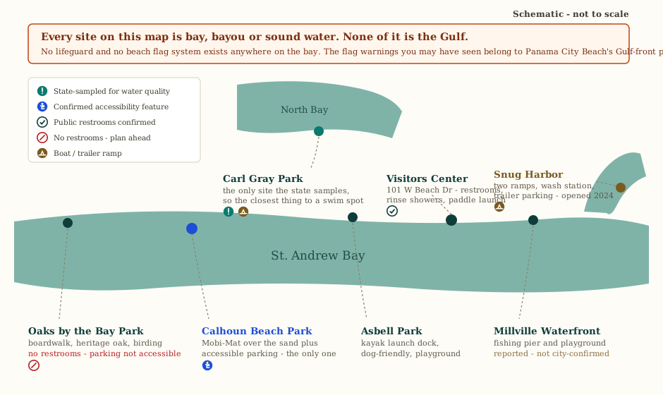
Decision framing
- Best for families: Carl Gray Park — the only site with official swimming and state water-quality sampling.
- Best accessible access: Calhoun Beach Park — the sole confirmed Mobi-Mat plus accessible parking. McKenzie Park is step-free but isn’t a water access point.
- Largest dependable parking: Snug Harbor Boat Ramp, by description — it was built around trailer parking. No site publishes a space count, so treat this as relative rather than measured.
- Quietest access: not determinable from sourced data — no site publishes visitor counts. As editorial judgment only, Millville Waterfront Park and Asbell Park are the least documented and least promoted of the eight.
- Fills earliest: there is no capacity data anywhere. The one dated pattern is that Oaks by the Bay’s small Beck Ave lot doubles as Saturday-market overflow (9am–1pm), so it’s under real pressure on market mornings, with no documented overflow lot or shuttle.
- Fees, hours, restrictions: no entrance fee is documented at any of the eight sites — free, unstaffed parks and ramps, with free surface parking. Individual hours are undocumented. Alcohol and off-leash-dog ordinances exist in Municode but their text could not be retrieved, so don’t assume either is allowed without confirming.
- Rideshare drop-off: Uber and Lyft operate here. Downtown and St. Andrews drop-offs are straightforward; the residential-edge bay parks (Carl Gray, Asbell, Snug Harbor, Millville) may see a slower return pickup — there is no sourced wait-time data, and we won’t invent one.
- Restrooms, showers, shade, boardwalk: confirmed restrooms and rinse showers only at the Visitors Center. Oaks by the Bay has none. Shaded picnic areas at Calhoun Beach Park and Asbell Park; a pavilion at Snug Harbor. Boardwalk at Oaks by the Bay (0.4 mile) and along Bayview Ave at St. Andrews Marina.
Sites that read as Panama City bay access but aren’t
A reader who includes any of these in a “Panama City water access” shortlist is comparing across different municipalities with different managing authorities and rules — and, at St. Andrews State Park, a different type of water entirely. None of the free-parking, no-lifeguard, no-fee logic that applies to a City of Panama City park transfers to a Bay County, Lynn Haven, or state-park site.
- Under the Oaks Park — a Bay County facility in Callaway, not a Panama City park; it shows up in generic searches because of its name.
- A.L. Kinsaul Park — in Lynn Haven, a separate municipality across North Bay.
- Daffin Park and Truesdell Park — genuinely inside Panama City, but inland. Daffin is a sports complex, under renovation per mid-2025 coverage; Truesdell is a neighborhood playground. Neither has water access.
- St. Andrews State Park — carries a Panama City mailing address (32408), hence the search overlap, but sits physically past Panama City Beach via Thomas Drive. A real, excellent Gulf beach — just not in the city you’re standing in downtown.
The marinas
Panama City Marina (downtown, 1 Harrison Ave, “the T-Dock”) is still closed to boaters. Michael damaged it; the city terminated its P3 and is running the rebuild itself. Bidding opened April 15, 2026 on the first 50 of a planned roughly 200-slip marina, with a commission recommendation expected July 2026. No reopening date has been announced.
St. Andrews Marina (3151 W 10th St, 850-872-7240) is open but actively under construction. Built in 1960, with bulkhead sections collapsing; the commission approved bulkhead reconstruction plus 44 new slips on February 11, 2026, and the construction contract on June 24, 2026, at roughly 18 months estimated, with a permit through July 2027. Around 50 slips were completed by April 2024; the planned end state is 150-plus. Since April 1, 2026, operations run under the city, St. Andrews Marina Partners, and Coastal Marina Management, with harbourmaster Jason Lent.
C.S.S. Yacht Basin is a separate private marina in St. Andrews (22 slips, 850-852-8851) with no showers, laundry, or wastewater on site — those are at St. Andrews Marina’s north end.
Snug Harbor Boat Ramp remains the best-documented working public ramp in the city while the two marinas sort themselves out.
The paddling launch network
St. Andrew Bay is a protected, state-designated aquatic preserve. The city installed kayak-launch docks at Asbell Park, Calhoun Beach Park, and Lake Huntington Park, with three more planned for the bay’s east side, under a $120,000 project (a state grant plus city funds) targeting completion by the end of 2023. Completion and usability in 2026 have not been reconfirmed, so we don’t state that all six docks function today.
Paddlers also launch from the Visitors Center, Oaks by the Bay, Carl Gray Park, and St. Andrews State Park. Operators: Bayside Rentals (paddleboards, hydrobikes, pontoons) and Glow Float (guided nighttime LED paddleboard tours).
Cost
No entrance fee is documented at any of the eight city sites — free public parks and ramps, with free surface parking. No source exists for launch fees at Snug Harbor. We publish no downtown or St. Andrews parking rate: the most recent reporting is two years old and new St. Andrews-area parking limitations effective January 16, 2026 could not be retrieved. Confirm all downtown and St. Andrews parking rates and rules with the city rather than trusting a figure found elsewhere.
The one hard, current fee here is St. Andrews State Park: $8 per vehicle (2–8 people), $4 single-occupant, $2 pedestrian or cyclist, $12–16 boat launch, per Florida State Parks, verified 2026-07-25 — verify current price. Tyndall’s non-DoD recreation permit has no reliable current price, so no figure appears on this page; verify it with Tyndall’s iSportsman portal directly.
Accessibility
Calhoun Beach Park is the single confirmed accessible water access in the city: a Mobi-Mat surface plus designated accessible parking. McKenzie Park is step-free with primarily flat pathways, but it has no documented water frontage — it solves a downtown-walkability need, not a bay-access one. Oaks by the Bay’s on-site parking is explicitly flagged as not accessible, which matters because its boardwalk is otherwise flat and would be a strong candidate.
Beyond those three data points, this is the largest documented gap in the guide. Carl Gray Park, Asbell Park, Millville Waterfront Park, Snug Harbor Boat Ramp, and the Visitors Center launch have no published accessibility information — not “confirmed inaccessible,” simply undocumented. We won’t infer accessibility where no source states it. Call City of Panama City Parks & Recreation directly for any site other than Calhoun Beach Park before planning a visit around it.
Families and age fit
Carl Gray Park is the clearest family recommendation: swimming is an official activity, the state samples the water, there’s a shoreline playground, and a boat launch and picnic areas round out a half-day visit. Oaks by the Bay suits a walk or a birding stop better than a swim stop — the boardwalk is flat and stroller-friendly, but there are no restrooms, so plan a bathroom stop elsewhere first. The Visitors Center is the practical answer.
The single most important thing for a family to know before wading in: there is no lifeguard at any of these sites, and no flag warning system on the bay at all. That conclusion is inferred from the complete absence of any official source describing lifeguard service at a Panama City bay park — stated here as the working assumption for trip planning, and flagged for direct confirmation with the city rather than treated as a guarantee. An adult is the safety system at every site, all the time. The bay’s calm, shallow water is genuinely lower-intensity than Gulf surf for small kids, but “calmer” is not “supervised.”
Weather and safety
No lifeguards, no flags — restated here because it governs every decision on this page. Any flag reference you see for “Panama City” belongs to Panama City Beach’s Gulf-front program, run by the City of Panama City Beach Fire Department and its Beach & Surf Patrol, which has no jurisdiction over, and no relevance to, bay conditions.
Water quality — the Healthy Beaches program. Carl Gray Park is the only City of Panama City site on the Florida Healthy Beaches sampling list, run by the Florida Department of Health. The program tests for enterococci bacteria, an indicator of fecal contamination, and rates results Good (0–35), Moderate (36–70), or Poor (71-plus) per 100 mL. Sampling runs roughly bi-weekly, and northern-tier counties, including Bay County, suspend sampling November through February — no live reading during that window regardless of conditions. Check the current result at floridahealthybeaches.com, the DOH map at fdoh.maps.arcgis.com, or by calling DOH-Bay at 850-481-4812. No other site in this guide is sampled — that’s a gap, not a clean bill of health.
Red tide. FWC’s statewide red tide status page updates daily at 5pm with the last eight days of sampling, plus a written regional report each Friday. As of 2026-07-25 the Northwest Florida regional report showed Karenia brevis not observed in the most recent sampling week — but that reading is regional, not bay-specific, and it’s a snapshot that changes. Check the week you travel at myfwc.com/research/redtide/statewide.
June grass does not affect these sites. The filamentous algae that shows up on Gulf beaches most commonly June through October arrives from the west, in the Gulf — it is not a St. Andrew Bay phenomenon and is not relevant to any site in this guide.
Hurricane season runs June 1 to November 30, peaking historically around September 10. Michael made a direct Category 5 hit on October 10, 2018, and its effects are still visible in the marina construction status above. Watch the National Hurricane Center in the week before any peak-season trip.
What can go wrong
- Assuming any bay park is guarded. None are — treat all eight sites as unsupervised water.
- Driving to a site that isn’t in Panama City. Under the Oaks Park (Callaway), A.L. Kinsaul Park (Lynn Haven), and St. Andrews State Park (past Panama City Beach) all read as “Panama City” in searches.
- Showing up to Oaks by the Bay without a restroom or accessible-parking plan. Neither exists on site.
- Assuming the kayak-launch dock network or the marinas are fully operational. The dock project’s 2026 status is unconfirmed; the downtown marina is still closed to boaters, and St. Andrews Marina is mid-construction with possible partial-access periods. Confirm the current status of each before a visit.
- Trusting a Carl Gray Park water-quality reading without checking the date. Sampling is bi-weekly and suspended entirely November through February.
- Treating Tyndall’s East Unit shoreline as walk-up. It needs an advance permit with a roughly two-week background check — not a same-day plan.
- Assuming a fixed drive time to St. Andrews State Park. The Hathaway Bridge is the only Gulf-side crossing and sits inside a multi-year widening project with a 35 mph work-zone limit. We publish road miles, not minutes.
Alternatives — the nearest real Gulf beach
St. Andrews State Park, 4607 State Park Lane, 32408 — a Panama City mailing address on a park physically past Panama City Beach. Open 8am to sundown, 365 days. Fees: $8 per vehicle (2–8 people), $4 single-occupant, $2 pedestrian or cyclist, $12–16 boat launch — verify current price. Gulf and lagoon beaches, jetties, nature trails, snorkeling, an amphitheater, a campground, and the in-park Shell Island ferry, which leaves the park’s own marina — a different boat from the Shell Island Shuttle at 5709 N Lagoon Drive, so book on the dock address — across five ecological landscapes. Route: Hathaway Bridge (US-98) into Panama City Beach, then Thomas Drive out the peninsula to the entrance. The bottleneck is the bridge itself — the single primary link between the two cities, inside Phase 3 of a widening project (four to six lanes, roughly four miles, targeting late 2030) with a 35 mph work-zone limit and doubled fines. We publish road miles, not a drive time: 13 miles downtown to Panama City Beach, with the park farther out the peninsula.
Shell Island is split three ways, not two, and which part you are on decides the rules. The western half is St. Andrews State Park. The eastern half is Tyndall Air Force Base, sharing a property line with the park. And in the middle, at the most popular boat anchorage on the island, sits a third jurisdiction that is neither: the Spanish Ante Subdivision of private lots and county roads. A description that names only the park and the base puts a reader on somebody else’s lot at the exact spot most boats stop. That halves-plus-subdivision wording rests on a single advocacy group with a stated adversarial history with the park rather than on a governing authority, and the caveat travels with it every time it is printed. Reaching the island means choosing a dock, because two entirely different boats leave two entirely different docks and the bare phrase Shell Island Ferry names neither: the in-park ferry from the marina inside St. Andrews State Park — St Andrews and Shell Island Adventures, 844-907-4355, with park admission paid at the gate before you reach the marina — and the Shell Island Shuttle from 5709 N Lagoon Drive on the Grand Lagoon canal front, (850) 233-0504. On the permit question we take no side in either direction: whether a ferry or shuttle passenger landing on the state-park half needs a Tyndall recreation permit is published by nobody — not either operator, not the park, not the base, whose pages never name the island and never draw the boundary — so ask the operator and Tyndall public affairs rather than reading anything into our silence. What is sourced is narrower than the question: the Tyndall permit regime is written for the base East Unit, so if you plan to reach the eastern half independently — by private boat, to fish, or by ranging east past the state-park half — check Tyndall’s iSportsman portal for current permit and ID rules before you go, as you should for anywhere described as the West Unit near Redfish Point or Davis Point. That end is an active military installation and federal trespassing rules apply there.
The Tyndall shoreline question. Tyndall’s regulations split the base into an East Unit and a West Unit — that line, not the base perimeter, governs public access. Certain East Unit shorelines (Tyndall Beach, Davis Beach, Buck Beach, Crooked Island East Beach, Bonita Bay, Shoal Point) plus certain boat launches are open to the public, only through an advance online iSportsman Recreation Permit that includes a background check.
Some Tyndall shorelines are legally open to the public, but not as a walk-up beach. Access runs through a paid recreation permit bought in advance on Tyndall’s iSportsman portal, which includes a background check that has taken about two weeks for visitors without a military affiliation. That makes it a plan-ahead option, not a same-day one. Nothing about buying a permit grants access to the flightline or the West Unit.
The West Unit and flightline remain DoD-only, via an in-person DBIDS card. Tyndall’s east-end section of Shell Island, and Crooked Island West, are reachable by non-DoD visitors only by boat or DoD escort — that rule governs Tyndall’s land, and it is a statement about the base’s own section rather than about what a passenger landing on the state-park half needs. US-98 through-traffic to Mexico Beach crosses Tyndall property on elevated flyover overpasses with no gate check in normal operations — a different thing entirely from setting foot on the shoreline.
A quieter alternative: Lynn Haven Bayou Park and Preserve, across North Bay in the separate City of Lynn Haven, offers a Deepwater Horizon-funded, ADA-accessible paved path network with a kayak and motorized launch. Its open status has not been cross-checked against a city source, so confirm before treating it as a live option.
| Panama City (bay) | Across the Hathaway Bridge (Gulf) | |
|---|---|---|
| Water type | St. Andrew Bay, North Bay, bayous — calm, shallow, no surf | Open Gulf — surf, deeper water |
| Lifeguards | None documented at any site | Yes, at Panama City Beach’s staffed guarded accesses |
| Flag system | None exists | Yes — City of Panama City Beach Fire Dept / Beach & Surf Patrol program |
| Water quality monitoring | One site (Carl Gray Park) on the state sampling list | Multiple Bay County Gulf-side sites sampled, for example PCB Access #41 and Rick Seltzer Park |
| Fees | None documented at city sites | St. Andrews State Park: $8 per vehicle, verify current price |
| Access type | Small free city parks and ramps | State park, plus numerous PCB public Gulf accesses |
| Getting there | Local streets, no bridge | Hathaway Bridge crossing required — the corridor’s single chokepoint, under multi-year widening construction |
The Gulf-side flag program belongs to the City of Panama City Beach and describes Gulf-front conditions only. It has no jurisdiction over, and says nothing about, any bay site in this guide.
Suggested plan — a car-based half-day
Start at the Visitors Center (101 W Beach Dr) for restrooms and rinse showers, and a Bayside Rentals paddleboard if you want one. Drive to Historic St. Andrews — Oaks by the Bay’s boardwalk for birding and the Sentry Oak (no restroom there, so use the one you already passed), then Calhoun Beach Park for the accessible Mobi-Mat, then the St. Andrews Marina boardwalk for the Pelican Tree. On a Saturday morning, arrive early — the Market at St. Andrews (9am–1pm) uses Oaks by the Bay’s lot. Finish at Carl Gray Park for actual swimming, checking the current Healthy Beaches result first.
Don’t build a Gulf swim into this half-day — that’s a separate trip across the Hathaway Bridge, and we don’t attach a drive time to it. Boaters: swap the St. Andrews stop for Snug Harbor Boat Ramp.
Freshness thresholds
| Claim type | Stale after | Behavior when stale |
|---|---|---|
| Marina construction status (all three) | 30 days | Replace with “status changing — verify with the city”; never show a stale reopening estimate |
| Parking rates, hours, and rules | 30 days in peak season, 90 otherwise | Suppress the figure, show the authority |
| Kayak-launch dock completion and usability | Recheck before every publish | Mark unconfirmed rather than complete |
| Healthy Beaches sampling result (Carl Gray Park) | Per the program’s own bi-weekly cycle; suppressed entirely November–February | Suppress the value rather than show a stale one |
| Tyndall permit price and area access | 60 days | Suppress the price, keep the process description |
| Red tide regional status | Daily (5pm update) | Show the sampling date; never carry a value past its week |
| Site-level accessibility, restroom, and capacity data still unsourced | Not yet sourced | Do not publish as fact until an authority confirms |
Sources and methodology
Every fact traces to the Region A research dossier, compiled 2026-07-25 — the only permitted fact base; no outside knowledge, search, or fetch was used. Sources reused here: City of Panama City facility pages (panamacity.gov); Florida DOH and Healthy Beaches (floridahealthybeaches.com, bay.floridahealth.gov); Florida State Parks (floridastateparks.org); Tyndall AFB’s iSportsman portal and public affairs (tyndall.af.mil); the WJHG news archive for marina and construction status; Destination Panama City (destinationpanamacity.com) for accessibility and launch-point details; Florida Hikes and the Great Florida Birding Trail for Oaks by the Bay; and FWC’s red tide status page.
Items without a dossier source are held as open verification items on this record and are unpublishable as fact until an authority confirms them. No firsthand site visit informs this guide — every operational claim is desk-researched, not observed.
Commercial relationships on this page: none. This page’s entire subject is safety-adjacent bay access and is therefore permanently ineligible for sponsored placement under BeachLetsGo’s monetization rules.
Related pages
Live conditions for this zone cover bay shoreline only. There are no lifeguards and no beach flag system anywhere on the bay, and Panama City Beach’s Gulf-front flag program does not describe conditions here.
- Live conditions: St. Andrew Bay / Panama City — /beach-today?zone=st-andrew-bay-panama-city
- Itineraries that use this guide: 3 Days in Panama City with Kids (/itineraries/panama-city-3-day-family) · 3 Days for Two in Panama City (/itineraries/panama-city-3-day-couples)
- Destination hubs: Panama City (/destinations/panama-city) · Historic St. Andrews (/destinations/panama-city/historic-st-andrews)
- First-time visitor guide: /guides/panama-city-first-time-visitor-guide
- Where to stay: /guides/where-to-stay-panama-city
Change history
| Date | Change |
|---|---|
| 2026-07-25 | Guide drafted against the Region A research dossier and the destination template’s in-depth guide structure. Not published — blocked on author and reviewer assignment and on the open verification items carried with this record. |
This zone covers bay shoreline only. There are no lifeguards and no beach flag system anywhere on the bay. This page is safety-adjacent access guidance and carries no sponsorship of any kind.
FAQs
Does Panama City have a real beach?
No. Its shoreline is St. Andrew Bay and two bayous — calm, shallow, no surf. The nearest Gulf beach is St. Andrews State Park, across the Hathaway Bridge, which carries a Panama City mailing address but sits physically past Panama City Beach.
Are there lifeguards on the bay?
No official source describes lifeguard service at any Panama City bay park. That is treated here as the working assumption for trip planning and flagged for direct confirmation with the city — not presented as a guarantee either way.
Which bay park can I swim at with confidence?
Carl Gray Park — the only one with official swimming status and state water-quality sampling.
Which access is wheelchair-accessible?
Calhoun Beach Park, with a Mobi-Mat and accessible parking — the only confirmed accessible water access in the city.
Can I visit Tyndall’s beaches on a whim?
No. East Unit shorelines require an advance online permit with a roughly two-week background check for non-DoD applicants.
Is St. Andrews Marina open?
Yes, under active phased reconstruction expected to run roughly 18 months from mid-2026. The downtown Panama City Marina remains closed to boaters entirely.